Oregon Dunes KOA
Because of DuneFest, the Oregon Dunes KOA was the busiest campground we’d been to up to that point. We seemed to be the only backpackers there and likely the only ones who went to bed before 10 PM. Trust me —Getting to sleep when your fellow campers are still revving their ATVs, chopping wood and generally carrying on has its challenges. We eventually made it work though.
Our plan for Day 14 was to hike to the beach on one of the dune roads then turn south. In retrospect, we probably should have asked around a bit before executing this plan but we seem to come up with all our good ideas after the fact.
Route 1341
From the KOA, we walked south on the 101 to Hauser Depot Road where we turned and headed west. Within a half-mile, we turned onto Sandy Road near a set of railroad tracks.

After another half-mile, we found the ATV road that promised to take us to the beach.

From here, the road became very sandy and the walking quite difficult.

The road was well-used by a host of ATVs, Razors, and sandrails that would zoom up on us, often at high speed. Thankfully, we could usually hear them coming so we could jump out of the way.

We learned the drill quickly — Shuffle, shuffle, shuffle through the sand; hear the engine roar; scramble up to the edge of the road; wave at the riders as they passed. Rinse. Repeat.

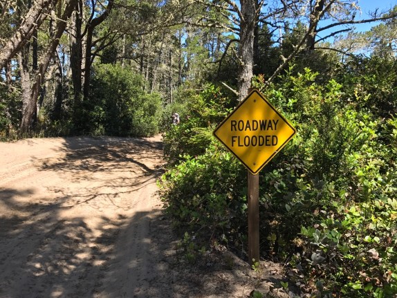
At a few points, there were water hazards to contend with.

Rhonda was our expert tracker in these cases. She would find the best way around the obstacle and the rest of us would follow. Typically, Christy would yell at me to do X and then I would Y but thankfully my stubbornness didn’t result in any unplanned mud baths for me.

While following the road, I tried to sync our path with the trail map on my phone. This worked well for a time but we eventually started to drift. At first, this wasn’t a concern as we were still on the road. When we walked by a lake that was nowhere near the road on my map, though, we knew we had a problem. We decided it was time to flag down an ATV rider and make sure we were going the right way.
That proved to be an educational conversation.
According to the riders we talked to, we could get to the beach from where we were but we’d have to walk several more miles first. Every other route was blocked by water. I’m guessing we could have learned the same thing had we asked someone at the KOA but it was a little late for that.
Based on flooded roads we’d already encountered and the marshes surrounding us (see below), the warning we received from the riders seemed fair.

Unfortunately, what all this really meant was that we’d just walked the last 2-3 miles for nothing. We had to turn back. After some colorful language, some minor weeping, and gnashing of teeth, we flipped around.
Back at Hauser Road, my Garmin watch displayed 5.4 miles but we’d officially made ZERO progress. Worse yet, we wasted a bunch of time we couldn’t get back. It was “fast-forward” time. We felt like we were cheating but our options were limited at that point. As we waited for a taxi, we figured we could drown our disappointment at the 7 Devils Brewery in Coos Bay.
7 Devils Brewing
7 Devils Brewing was one of my favorite stops along the coast. The restaurant was beautiful and the beers and food were excellent.


After enjoying the excellent Blacklock Porter and Green Fig Stout, all was ok in the world.

Coos Bay to Charleston
After 7 Devils, we walked to a Bi-Mart store in Coos Bay to get some supplies, then it was on to the town of Charleston. We took a shortcut on Libby Lane, which proved to be a bit treacherous at times.

As you can tell, we didn’t have much of a shoulder to use on Libby Lane. When cars would come by, we would often have to dart off the road to let them pass. It was a nerve-wracking walk, to say the least.

After another 8 miles, we finally made it to Charleston.

Walking into town, I snapped a picture of a statue that might only make sense to those of us who grew up in the 70’s and 80’s — Charlie the Tuna!

Charleston to Sunset Bay
We did run into a magnificent hydrangea bush along the way.

And eventually, a much welcome sign announcing the entrance to Sunset Bay State Park.

Walking the Cape Arago Highway to the park, we met a woman named Karen who would soon become a “trail angel” for us. I’ll save that story for tomorrow’s chapter though.
Sunset Bay State Park is very close to Cape Arago, some of which we should have been able to see from the beach. Unfortunately, the fog obscured our view.

Grrr… Perhaps tomorrow.
We made camp in the park, ate dinner and even had a nice fire. The fire was courtesy of the park hosts who were impressed enough by our journey that they gave us a bundle of wood. Even better, we had a neighboring camper donate a burning log as well as his fire-starting skills to get us going. We continued to be blessed with trail magic.

Day 15 mileage was 17.9 with 902 feet of elevation. Total distance to this point — 240 miles.